The Bondi to Coogee coastal walk is a victim of its own perfection: it is so geographically spectacular that it has become an international thoroughfare, crowded to the point where the act of walking becomes an exercise in pedestrian traffic management. For those who seek the harbour without the audience, who prefer the shade of coastal angophoras to the exposure of the eastern cliff tops, Sydney offers alternative routes of equal scale and vastly superior solitude.
The walks detailed below are not short promenades. They require three to four hours, proper footwear, and a willingness to navigate tracks that are sometimes steep and often uneven. The reward is a version of Sydney Harbour that feels almost private — hidden beaches, colonial military ruins reclaimed by the bush, and vantage points where you are likely to be the only person looking at the water.
The Spit to Manly (The Classic, Extended)
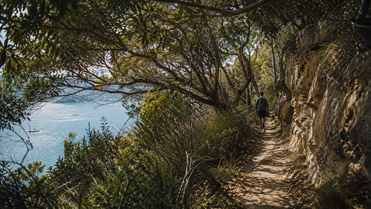
While the Spit to Manly walk is well known, its ten-kilometre length naturally filters out the casual walker. The track traces the northern edge of Middle Harbour, weaving through the Sydney Harbour National Park, dropping down to small coves, and climbing up to sandstone bluffs that offer long views back toward the city.
The true value of this walk is the geographical isolation it achieves within the metropolitan boundary. At points like Grotto Point or the descent into Crater Cove — where a cluster of historic, illegally built depression-era shacks still sit precariously above the water — the visual evidence of the modern city vanishes entirely. You are walking through dense coastal heath, with water monitors crossing the path and the sound of the harbour muffled by the trees.
The correct conclusion to the four-hour walk is not the immediate ferry back to the city, but a long, restorative lunch at one of Manly’s waterfront tables before returning across the harbour at sunset.
Distance: 10km (approx. 3.5 – 4 hours). Difficulty: Moderate, with significant stair climbs.
Taronga Zoo to Balmoral Beach (The Lower North Shore Traverse)
This route is less continuous bushland than the Spit to Manly, instead offering a curated transition between national park, hidden military history, and some of the most expensive residential real estate in the country.
Beginning at the Taronga Zoo wharf, the track rounds Bradleys Head — offering the sweeping, unimpeded view of the CBD and Opera House mentioned in The Elevated Picnic — before heading into the dense bushland of the Chowder Bay headland. The path descends into Chowder Bay, a preserved nineteenth-century submarine miners’ depot that now houses several excellent waterfront restaurants, making it the ideal halfway point for coffee or lunch.
The final section climbs over Georges Head, where extensive World War II fortifications are cut deep into the sandstone cliffs. These tunnels and gun emplacements are dark, cool, and open to exploration. The track then descends gracefully into the sheltered, Mediterranean calm of Balmoral Beach.
Distance: 6.5km (approx. 2.5 hours). Difficulty: Easy to moderate.
Hermitage Foreshore Walk (The Eastern Suburbs Secret)
At 1.8 kilometres, the Hermitage Foreshore Walk in Vaucluse is the shortest route on this list, but it is included because it provides the highest concentration of exceptional views per metre of any path in Sydney, and it remains inexplicably quiet.
The track threads a narrow line between the waterfront mansions of Vaucluse and the harbour itself, suspended on boardwalks over the water or cutting through small patches of remnant bushland. It passes Milk Beach and Queens Beach — small scallops of sand that look directly across the water to the Harbour Bridge.
The light here in the late afternoon is extraordinary. Because the track faces west across the harbour, it catches the full warmth of the declining sun, turning the sandstone gold and putting the city skyline in sharp silhouette. It is a walk that feels less like exercise and more like a private architectural and geographical tour.
Distance: 1.8km (approx. 1 hour). Difficulty: Easy.
The Resolute Track, Ku-ring-gai Chase National Park
For genuine isolation, you must drive forty-five minutes north to Ku-ring-gai Chase National Park. The Resolute Track begins at the West Head lookout and descends through dense, ancient eucalyptus forest to the water of Pittwater and Broken Bay.
This is a walk of historical and cultural weight. The track passes significant Aboriginal engraving sites — the Red Hands Cave is a detour worth taking — and the bush here feels older, denser, and more imposing than the harbour foreshore. The track eventually drops down to Resolute Beach, an expanse of sand accessible only by foot or boat. You will frequently have the beach entirely to yourself, with nothing but the water of Broken Bay and the distant outline of the Central Coast visible.
Distance: 6km loop (approx. 3 hours). Difficulty: Moderate, steep return ascent.
The Protocol of the Long Walk
The Timing: For the harbour walks (Spit to Manly, Taronga to Balmoral), start early — ideally by 8:00 am — to complete the walk before the midday heat and to ensure the beaches at the conclusion are reached when they are most appealing.
The Provisions: Assume you will not encounter a café for the middle two hours of these walks. Water is non-negotiable. A piece of good fruit and a small supply of almonds or dark chocolate are the correct fuel.
The Observation: These tracks reward the quiet walker. The native birdlife — kookaburras, rainbow lorikeets, the occasional sea eagle — will vanish if you announce your presence too loudly. Walk softly, speak quietly, and allow the environment to reveal itself.